How fast did sea levels rise after the last ice age?
Until now, the rates and extent of sea level rise during the early Holocene were poorly understood because of a lack of sound geological data from this period. Researchers from Deltares, the Netherlands Organisation for Applied Scientific Research (TNO) and, among others, Utrecht University, Delft University of Technology, the Netherlands Institute for Marine Research, Wageningen University and Research and the University of Amsterdam have now been able to draw on a unique dataset from the North Sea region to make highly accurate estimates of sea level rise in the early Holocene for the first time. The results of their study were published today in the leading journal Nature.
Want to read more?
Global sea level rise: 37.7 metres
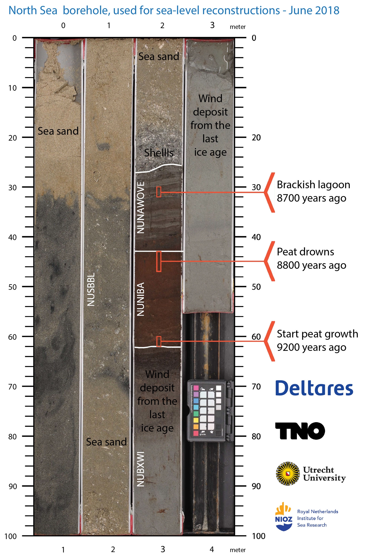
The researchers analysed data from the area that was once Doggerland, a land bridge between Great Britain and mainland Europe. This area flooded as sea levels rose.
By analysing the peat layers from this area, dating them and applying modelling techniques, the researchers showed that, during two phases in the early Holocene, global sea level rise briefly peaked at more than a metre per century.
They also concluded that global sea levels rose by as much as 37.7 metres between 11,000 and 3,000 years ago, clarifying previous discrepancies between ice sheet reconstructions and sea level data for this important period.
'This research helps us better understand sea level rise after the last ice age. Thanks to unique North Sea data, we can better comprehend the interaction between ice sheets, climate, and sea level, which is valuable for scientists and policymakers.'
Unique dataset from the North Sea area
Marc Hijma, a geologist at Deltares and the lead author of the study: 'With this groundbreaking research, we have taken an important step towards a better understanding of sea level rise after the last ice age.
By drawing on unique data from the North Sea region, we can now better understand the interaction between ice sheets, climate and sea level. This provides insights not only for scientists but also for policymakers so that we can prepare better for the impacts of current climate change.'

'Thanks to our North Sea data, we were able to precisely drill the desired peat and clay layers and accurately map the subsurface. This data is crucial for the geology of the North Sea and the energy transition.'
Freek Busschers, geologist at TNO: ‘This research was only possible thanks to the data from the North Sea that we manage. It allowed us to precisely drill into the targeted peat and clay layers and accurately determine where we could conduct seismic surveys.
Our data contributes to the knowledge of the geology of the North Sea, which is important, for example, in the context of the energy transition. In the future, we want to study even older warmer climate periods that are comparable to the one we are currently living in and may give us an insight into what the future will look like.'
Better understanding of sea level rise
The study helps to close the gap between previous reconstructions of ice sheets and sea level data, which were often contradictory.
The findings are of major importance for our current understanding of sea level rise and they provide valuable insights for the future. Given the current rise in greenhouse gas concentrations, climate models predict that sea levels will rise several metres by 2300, with some scenarios indicating a rise of more than one metre per century.
The rate of sea level rise in the early Holocene now provides an important reference point for scientists and policymakers, allowing them to better understand, and prepare for, expected rises in the future.
Curious about how the drilling was carried out?
Contact us
-

Freek Busschers
Functie:Geologist-
Standplaats:Utrecht - Princetonlaan
-
Email:Email Freek
-
Get inspired
TNO and partners launch project to accelerate longduration energy storage in the Dutch energy system
CRM materials and processes

TNO–SodM–NIOZ: ‘Methane emissions in the North Sea often linked to shallow natural gas’
Heat

Geothermal energy: sustainable heat from the subsurface